

Fishing Lake
October 14, 2026 Update
The Water Security Agency (WSA) continues to monitor Fishing Lake levels and operate the emergency channel to maximize outflow. Recent surveys found water-level differentials of 5 cm or less at the Margo grid, pasture approach, and gated control structure. This information indicated that these locations are not restricting the channel’s flow capacity.
Technical assessments for sediment removal in the emergency channel are underway, and federal permitting with Fisheries and Oceans Canada is nearing completion. The proposed work will also assess the former weir site. Because the channel gates must be closed during the work, timing is critical. Completing the work now would interrupt current releases during the remaining open-water season. The work is therefore being planned to balance potential improvements against the temporary loss of outflow.
Targeted vegetation removal in the emergency channel and earlier work at the weir site have already been completed. Sediment removal is expected to improve channel conveyance, but it will not provide an immediate or complete solution to high water levels.
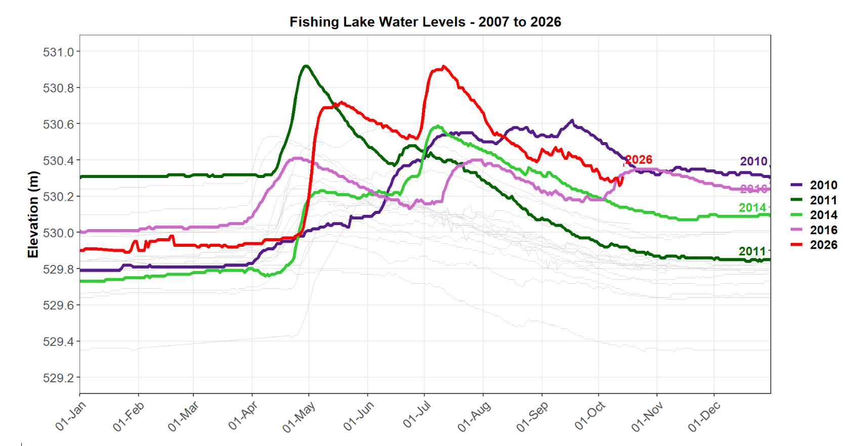
Forecasts indicate that the lake levels may decline to approximately 530.20 metres by freeze-up, although future rainfall and runoff conditions will continue to influence lake levels. This level is similar to those recorded in the fall of 2015 and 2017. As outflows are able to continue, the forecasted levels for freeze-up will continue to be updated by staff. The forecasts are based on historic data provided in the figure attached.
WSA recognizes the ongoing effects of high water on residents and property owners. We will continue working with local partners to support property-protection efforts, provide timely information and advance practical short- and longer-term measures to improve lake-level management.
The next update on this project is expected by October 28, 2026.
Current Conditions
Summer rainfall in 2026 has caused Fishing Lake to reach record high water levels. The Water Security Agency (WSA) continues to actively manage levels in collaboration with the local Watershed Association.
For the last two years, gates in the emergency channel have been left open to assist with the flow of water through the system. By fall 2025, lake levels had returned to the emergency channel spill elevation. However, overwinter conditions, late spring snowstorms, higher than normal runoff and now heavy rains in the area have combined to create abnormal conditions on the lake.
As a result of June and July rainfall, the lake approached 531 metres, surpassing the previous record high water level of 530.8m observed in 2014. Sand bagging efforts around some areas of the lake were in response to wind and wave action, but further efforts could be needed if the lake continues to rise.
Local Rural Municipalities are currently working with WSA and the Saskatchewan Public Safety Agency to coordinate a response. If property owners around the lake observe an immediate threat, please contact your local Rural Municipality or Resort Community Office for assistance.
WSA and local stakeholders had been actively working to lower lake levels in the months leading up to the influx of rainfall. When runoff from the area began entering the lake in early May, channel gates were already open to facilitate as much water movement through the system as possible. However, due to the flat nature of the area, only minimal outflow could be achieved. The decision was then made to remove the weir at the southeast corner of the lake to further enhance the movement of water.
Even with these enhanced efforts, water levels in the lake will remain higher than normal for the foreseeable future due to the naturally flat lay of the land that does not allow for rapid movement of water through the system.
Fishing Lake – Frequently Asked Questions (FAQ)
Why are water levels at Fishing Lake high?
Fishing Lake is a semi-closed basin, meaning that it has no defined outlet, and water movement is restricted by the flat prairie landscape. As a result, the lake naturally experiences significant fluctuations in water levels depending on annual snowmelt runoff and rainfall.
How are water levels managed at Fishing Lake?
Water levels at Fishing Lake are driven mainly by natural conditions, including runoff, rainfall, snowmelt, lake storage, and the limited amount of water that can leave the lake through outflows.
In 2011, an emergency channel was constructed to help reduce high water levels after the lake reaches peak levels. The system is designed to supplement the natural path, with the emergency channel providing additional capacity when lake levels are above the natural spill elevation. Currently, the emergency channel is operating as it was designed, allowing for increased outflows when water increases above the natural spill elevation of Fishing Lake.
How does water flow out of the lake?
Water flows out of Fishing Lake through the flat area on the southeast towards Hazel Lake. From there, the natural channel moves water to Usinneskaw Lake (Stony Lake) and then from Stoney to Whitesand Lake. In 2011, a gated emergency outlet channel was constructed to help alleviate high water levels. The emergency channel bypasses Usinneskaw Lake and moves water directly from Hazel to Whitesand. The channel was designed to help increase the natural outflow from the lake during high inflow years, but not to draw down water levels in anticipation of increased inflow.
If the gates are open, why is the lake not dropping faster?
Opening the gates on the emergency channel helps water leave Fishing Lake, but it does not mean the lake will drop quickly. Fishing Lake is in a very flat landscape, so water naturally moves through the system slowly. Even when the emergency channel is open, outflows cannot be increased to a level that will see an immediate impact on the lake. Water levels will stay high for an extended period because there is limited natural slope to move water away quickly. Further, continued inflows from runoff, rain, creeks, and the surrounding watershed may offset some or all of the water leaving the lake.
What is being done to increase outflows from the lake?
WSA is taking additional steps to improve outflow, including work to fix and modify the weir in 2024 followed by fully removing the weir at the southeast corner of the lake. WSA and the Fishing Lake Watershed Association have worked together to remove vegetation from 800 meters of the emergency channel to improve the flow of water. Efforts were also taken to remove debris from the areas around five culverts that could impact flow.
Additional assessment and modelling are underway to determine whether sediment removal from the emergency channel could provide further benefit. Regulatory approvals are being pursued for potential sediment removal activities later in 2026.
These actions can help, but they are not expected to create an immediate drop in lake level. It may take months before the full effect is seen. Even when these steps are completed, the lake can only be drawn down to the natural spill elevation. Any further decrease to lake levels can only be achieved by evaporation.
Where does the water flowing into Fishing Lake come from?
Fishing Lake is on the south side of a large basin. Most of the water flowing into the lake comes from a large contributing area on the north side of the lake.
Where can I find current water level data?
Current lake and stream information is available through WSA’s official monitoring and reporting tools, including Stream Flows and Lake Levels. Click here and select Fishing Lake from the list of monitoring stations. During active conditions, WSA reviews monitoring information regularly and provides updates when there are meaningful changes in lake levels, flows, weather, or operational actions.
What is being done to address concerns about flooding?
WSA is actively monitoring conditions and working with the Fishing Lake Watershed Authority, Fishing Lake First Nation, the local Rural Municipalities, and other partners. Current actions include keeping outlet gates open, checking for debris or restrictions, removing the southeast weir to improve outflow, and planning downstream channel clearing. These steps are intended to move as much water as the system can carry. However, because the area is naturally flat and the outlet has limited capacity, there is no single action that will quickly lower the lake. WSA will continue to assess conditions and share updates as work progresses.
WSA encourages property owners to continue to work through their local municipality to access sandbags and support through the Saskatchewan Public Safety Agency and Provincial Disaster Assistance Program.
WSA is working closely with the local municipalities and other government agencies to identify and explore other potential options, and we intend to continue to communicate and update the communities and residents.
Where can I seek assistance for flooding impacts?
The Government of Saskatchewan flooding support website provides information and resources to those experiencing flooding. Flooding Support | Emergency | Government of Saskatchewan.
If you are experiencing flood damage or are at imminent risk of flooding, there may be programs available to provide support. The Water Security Agency offers the Emergency Flood Damage Reduction Program (EFDRP) to provide cost-shared support for permanent flood mitigation and temporary pumping to protect buildings and groundwater wells from imminent risk of flooding. The program is available to individual property owners, businesses, and municipalities. Eligible projects may receive 50% cost-shared funding up to a maximum grant amount of $50,000. For more information on EFDRP, please contact WSA’s Client Services at 1-866-727-5420.
The Provincial Disaster Assistance Program (PDAP), administered through the Saskatchewan Public Safety Agency (SPSA), supports residents, small businesses, agriculture operations, First Nations, non-profits and communities recovering from natural disasters such as floods, tornadoes, plow winds and other severe weather events. To access PDAP, contact your local municipality or First Nation. Municipalities are encouraged to contact PDAP directly as soon as a disaster event occurs.
What is the Fishing Lake Watershed Association and what is their role in managing water levels?
A watershed association is a local government body established under The Watershed Associations Act. It allows municipalities and other local organizations to jointly plan, fund, and manage projects that provide shared watershed benefits.
The Fishing Lake Watershed Association was formed in 1997 and includes the RM of Sasman (including North Shore and Ottman-Murray Beach), RM of Foam Lake, Resort Village of Chorney Beach, and Resort Village of Leslie Beach. Its board includes representatives from each member organization, and oversees the association’s activities, finances, and decisions, and works with WSA to maintain and operate the emergency channel.
What is the role of upstream drainage in lake levels?
In high run-off years like this Spring, the amount of water from snowmelt and runoff is the main factor driving lake levels. When areas are already saturated, like soil, wetlands, and drainage systems, water moves across the land in similar ways whether areas have additional drainage or not.
What impact could wind and waves have on flooding?
Fishing Lake is prone to damage from wind and wave action, especially when water levels are high. Strong winds can push water toward exposed shorelines, causing waves, erosion, debris movement, and temporary increases in water levels along parts of the lake. This means damage can occur even when the lake is below a previous peak or below the top of a berm. Residents are advised to use caution near the shoreline, secure loose items, avoid unstable or eroding banks, and monitor local weather and lake conditions. Property owners concerned about immediate flood risk should contact their local municipality, Saskatchewan Public Safety Association or WSA.
Who is responsible for shoreline protection?
Shoreline protection can involve several parties, depending on the location, land ownership, type of work, and whether the issue is emergency flood protection or longer-term shoreline stabilization. WSA can provide information on water levels, flood risk, outlet operations, and potential eligibility for emergency flood mitigation. However, WSA is not always the landowner or the authority responsible for completing shoreline works. Where shoreline areas involve Crown land, public land, municipal land, private property, or areas connected to First Nation, federal, provincial, or local responsibilities, residents may need to work with the appropriate landowner or authority before work can proceed.
What is WSA doing to reduce risk before next year?
WSA will continue to review lake conditions, outlet performance, and opportunities to improve how water moves through the system. This includes ongoing coordination with the Fishing Lake Watershed Association, Fishing Lake First Nation, the local Rural Municipalities, Manitoba, and other partners. Planned and potential work may include monitoring the emergency channel, clearing restrictions where appropriate, reviewing operational information from the current high-water period, and identifying practical steps that could reduce risk before the next runoff season. Because Fishing Lake is strongly influenced by natural runoff, weather, and limited outflow, no single measure can remove the risk of future high-water events.
Have the water levels been this high before?
Fishing Lake has had water management challenges for many years. The current high-water event is part of a long-standing issue that governments, local partners and Manitoba have worked on for decades.
The initial work to develop a drainage project to lower lake levels during times of high water began in 1997. This earlier work is what led to the formation of the Fishing Lake Watershed Association in August 1997. However, the threat of flooding diminished in following years until 2006 when flooding issues resurfaced.
In 2007, Fishing Lake experienced flooding that impacted between 400 to 500 cottages and homes. A series of berms were constructed in response to the flooding event, and in 2011 an emergency outlet channel was constructed.
What is the Agreement with Manitoba?
The Agreement with Manitoba is an operating agreement that guides how the Fishing Lake Flood Relief Channel is managed. It was established to help reduce flood risk around Fishing Lake while minimizing impacts downstream in Manitoba. The agreement sets out how Saskatchewan and Manitoba work together, establishes a Joint Operating Committee to review conditions, and provides the operating rules that guide when and how water can be released through the channel.
Could the outlet channel be improved to increase outflows from the lake?
WSA has taken additional steps to improve outflow, including removing the weir at the southeast corner of the lake and planning channel clearing work downstream. Fishing Lake is in a very flat landscape, so water naturally moves through the system slowly. WSA continues to explore other options to increase flows.
How will WSA keep residents informed?
WSA will continue to share updates through official channels, including this Fishing Lake webpage and WSA Client Services. Updates will focus on meaningful changes in lake levels, flows, weather, outlet operations, flood protection information, and planned work. WSA will also continue to coordinate with local and regional partners so information can be shared through appropriate community channels. Residents can submit questions through WSA Client Services, and those questions may help inform future public updates or additions to this FAQ.
Who can I contact with additional questions?
For questions about lake conditions, residents can contact Water Security Agency Client Services at 1-866-727-5420. For questions about disaster recovery assistance through PDAP, residents should contact their local authority or the Saskatchewan Public Safety Agency.
Fishing Lake is a closed basin lake located in east central Saskatchewan, southeast of the community of Wadena. Home to several cottage developments, the lake is a popular summer retreat.
As a closed basin lake, water levels are determined by inflows from the surrounding area and are not controlled by a traditional barrier such as a dam. Due to the relatively flat nature of the topography, there are minimal outflows from the basin. The lake relies on evaporation, movement of water through the natural system and through the flood relief or emergency channel to manage higher water levels when needed. Operations of the flood relief channel may not reduce peak water levels in Fishing Lake. Instead, it was designed to facilitate the movement of water out of the system once lake levels begin to recede. By increasing outflow after the peak, the channel accelerates the drawdown rate, reducing the duration of prolonged high water conditions. While elevated water levels may still take several months to fully recede, operation of the channel shortens the overall recovery period. The outlet itself is very flat and marshy which naturally limits how quickly water can move out of this lake.
Historically, lake levels are a concern for cottage owners and the local Fishing Lake First Nation. The Water Security Agency has been working with stakeholders in the area for years, including the First Nation, cottage owners and the Fishing Lake Watershed Association. WSA has assisted with the installation of berms around the lake to address areas prone to flooding and constructed a downstream channel to assist with moving excess water.
Even when water levels remain below the flood protection berms, high winds can create strong waves, particularly during the open water season. Strong winds can generate waves and wind driven water movement, temporarily raising water levels or causing wave run up that may exceed the berms. This can result in localized shoreline flooding, particularly in cottage developments, even when overall lake levels are not higher than the flood protection infrastructure.
Since fall 2024, WSA has worked collaboratively to improve water level management at the site. These efforts included removing sheet pile from the weir and operating the emergency channel gates continuously to increase outflow. Over the past two years, WSA and the Province of Manitoba agreed to keep the gates open throughout the winter to support ongoing water level management. These combined actions have contributed to lower lake levels through the summer of 2025.
While efforts have been made to address concerns from residents, WSA continues to research potential long term solutions including the collection of additional hydrometric data, the use of drone footage to identify areas that may constrain water flows, and the evaluation of potential options for channel clearing and silt removal where feasible.
We remain committed to working with partners and keeping local communities informed as conditions evolve.
An Experienced Team
We love our Saskatchewan waterways, and we also know a lot about them. If you need help finding information or determining if your shoreline or water-related project needs a permit, we can help! Use the contact form or give us a call to get started.